


|
The Zambezi River Legacy,
|
Near the town of Mwinilunga in north western Zambia is a famous hill. It’s called Kaleni Hills made popular by the early missionaries who settled there. It’s near this hill, albeit some 48 odd kilometers away, that the Zambezi derives its water. This source is a spring with unimpressive start. But that’s how big things start. Small!
The tiny spring bubbles between roots of a small tree. The older tree has now fallen down replaced by a younger tree. The water from the spring does not flow way but instead it sinks again into an underground river, which outcrops 10 metres away. This second ‘spring’ also sinks down only to appear 30 metres down the slope. There the river flows on surface and becomes wider and larger as it covers more distance. 48 kms down stream the river is large and powerful cuts into rocks to form the Zambezi Rapids near the border with Angola. Then it enters Angola for about 300 kms.
The Zambezi Floodplain; Barotseland
After leaving eastern Angola the river re-enters Zambia near Chavuma town. At this point it forms at Chavuma Falls. This marks the end of its upper course. From its upper course, a distance of over 800 km (500 mi), the Zambezi falls only about 180 m (600 ft).
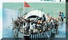
The Zambezi River enters and meanders in the Barotse Floodplain for a distance of about 190 kms. The Barotse Floodplain is the site of the world famous Ku-omboka traditional ceremony of the Lozi people who live there. Ku-omboka means leaving the flooded plain to high ground during the height of the rainy season about February/March.
 After leaving the floodplain the Zambezi pours its large volumes of water over the Ngonye Falls just outside the floodplain in a rocky countryside. For the next 100 kms (60 mi) below its confluence with the Kwando (Cuando) River, the Zambezi is a large smooth flowing channel.
Then suddenly it becomes a massive torrent at the cataracts called the Victoria Falls locally known as “Mosi-Oa-Tunya” which translates to “the smoke that thunders.” For 72 km (45 mi) the Zambezi rushes through a zig zagging narrow gorges 122 m (400 ft) deep. The gorges form part of the adventure centre where white water rafting, river boarding, bungi jumping, gorge swinging, etc, take place.
Lake Kariba
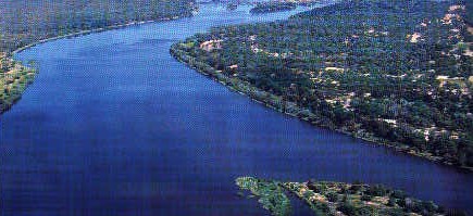
After about 90 kilometres the water of the Zambezi is trapped, only partly, in a large man-made sea, the Lake Kariba The dam was built near Kariba Gorge (1955-58) and holds water in a reservoir measuring 281 kms by 40 kms at its widest. It was Africa’s largest man-made lake until 1971 when the Aswan in Egypt was built. Kariba Dam generates hydroelectricity for Zimbabwe and Zambia including the surrounding countries.
Lower Zambezi River
A further 120 kms down stream the river gets a recharge from the Kafue another great Zambian river. With its source in the Zambian Copperbelt the Kafue traverses through the centre of the Copperbelt and turns southwards. It’s joined by the Lufunga River in the Busanga Floodplains , a wetland and Zambia’s greatest ‘antelope country’.
Further downstream the Kafue is dammed into Lake Itezhi Tezhi. It then overflows eastwards through the Kafue Flats on its way to join the Zambezi. The Kafue flats hosts the Blue Lagoon National Park in the south and Zambia’s largest bird sanctuary the Lochinvar National Park in the north.
In its middle course after the Victoria Falls the Zambezi flows through hilly country for about 1,300 km (800 mi) before it enters Mozambique at the confluence with Luangwa River. The Luangwa valley is the location of Zambia’s premier national park which is named after it. The Luangwa River is the second largest tributary of the Zambezi in Zambia. It meanders along its valley creating many ox-bow lakes. These lakes are the wildlife attractions in dry season. Wildlife and birds congregate around them in search of water.
Zambia African Safari © ZAS 2004